
40-tägige begleitete Radtour durch ganz Madagaskar von oben bis unten (Route 1 – Abgelegene wilde Wunder)
2 Monate ernsthafte Fahrrad-Odyssee, unterstützt und mit Glamping-Camping, durch die am wenigsten besuchten Teile der Insel, von Kopf bis Fuß, durch ihre besten Plätze.

40-tägige begleitete Radtour durch ganz Madagaskar von oben bis unten (Route 2 – Zentrale Kulturachse)
2-monatige Reise über die gesamte Insel zu den wichtigsten Kulturstädten und Sehenswürdigkeiten – Routenoption 2.
 – Overlanding by Off-Road Car from Nosy Be South to Maroansetra and Masoala")
Madagascar Real Frontier Tour (The toughest trip on the island) - Overlanding by Off-Road Car from Nosy Be South to Maroansetra and Masoala
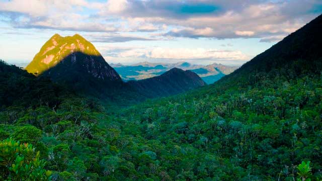
Very rough and real serious exploratory adventure trip from Nosy Be south, where no tourists go and where there is little to zero infrastructure. The road less (or never) traveled. This is the single hardest trip you can do in the country, and the most remote area with the people least-visited by tourists from the outside.

Madagascar Real Frontier Tour: Overlanding by Off-Road Car and Canal Boat from Tamatave South to Farafangana and Manakara
Very rough and real serious exploratory adventure trip from Tamatave south, where no tourists go and where there is little to zero infrastructure. The road less (or never) traveled.

Madagascar Real Frontier Tour: Overlanding by Off-Road Car from Tamatave North to Maroansetra and Masoala
Very rough and real serious exploratory adventure trip from Tamatave north, where no tourists go and where there is little to zero infrastructure. The road less (or never) traveled.

Madathon Marathon: Kayak Hike and Bike Through all of Madagascar Overland
2 month trip combining cycling, jungle hiking, trekking, sea kayaking, and road cycling all of Madagascar from top to bottom, in style